Monday, December 30, 2013

Pond Design and Construction
Ponds are built for a variety of reasons, but two basic rules remain the same. The pond must be sited on suitable soils and properly constructed to hold water, and there should be enough water available to fill the pond but not in great excess. Careful attention and expert advice on pond site selection and construction are essential. Once a pond is built, proper maintenance extends its useful life and beauty. In addition, most farm ponds depend on runoff from their watershed (land uphill from the pond) to fill and maintain the water level. Protecting the watershed ensures a quality supply of water to the pond.
For ponds built for recreational fishing, there is no advantage in deep ponds (over 12 feet to 14 feet deep) or to a deep area within the pond. Deep ponds are not more productive and tend to have more oxygen problems. Ponds should not have extensive shallow areas (less than 3 feet deep) unless aquatic plants are desired. Constructing ponds to drop off rather quickly to a depth of at least 2 1/2 feet helps prevent aquatic weed growth.
The Natural Resources Conservation Service (NRCS) publication "Ponds - Planning, Design, Construction" contains detailed information on design surveys, site selection, drainage area, pond layouts, soil analysis and spillway construction.  It is recommended that you contact the NRCS for assistance in pond site selection and construction, to make sure the site, watershed, and soils are adequate.  NRCS can ensure that you select the best location for your pond.  Additional information on pond design and construction as well as other aspects of pond management in Arkansas is available in the publication "Farm Pond Management for Recreational Fishing".

Design and construction of pond farms

1. Type of ponds based on source of water supply
Springwater ponds, seepage water ponds, ponds fed by rainwater or run-off, ponds fed by water courses and tide-fed ponds; barrage ponds and diversion ponds - rosary or linked ponds and parallel ponds.

2. General layout of pond farms
Ponds (nursery, rearing, holding, brood, catching, transition or stunting ponds); water control structures (dikes, canals and sluices); and supporting facilities (roads, bridges, culverts, workshop, stores, farmhouses, etc.).

3. Planning of farm layout
Preparation of farm layout plan, including water control system, based on physical features of the area, climatic conditions and requirements of farm management (production of fingerlings, table fish from either fry stage or fingerling stage); calculation of area required for nursery space; proportion of nursery ponds to production ponds, proportion of rearing pond area for different stages of rearing and area of holding ponds; determination of shape, size and depth of ponds; advantages of small and large ponds; optimum size of ponds for small-, medium- and large-scale culture operations; arrangement for adjustment of water level and salinity range of individual ponds in coastal farms.

4. Preparation of work plan
Quantification of input requirements; cash estimates; organizing supply of materials, labour and machinery; preparation of work schedule.

5. Site survey
Preparation of contour map; marking out the farm area; survey instruments required - levelling instrument with levelling staff, direct reading tachymeter with staff, theodalite, optical square, bevel protractor, tape and marking staff.

6. Site clearance
Clearance of vegetation from farm site by underbrushing, withering, felling and burning; removal of stumps; collection and later utilization of surface organic deposits as fertilizer or for facing embankments.

7. Design and construction of water control structures

7.1 Water control structures
Water gates and canals, levees or perimeter dikes and subsidiary dikes.

7.2 Basic principles for design
Calculation of water requirements; filling and drainage of pond farms; use of pumps, gravitation and/or tidal force for water supply and drainage.

7.3 Basic data required
For all farms - topography, soil properties, water supply, evapo-transpiration, seepage, magnitude of floods, rainfall, storms and cyclones; for coastal farms only - tidal range, river discharge, ground elevation and designed datum level.

7.4 Design and construction of dikes
Determination of height, top width and based width of dikes; slope of dike in relation to soil type; construction of dike foundation and wall; measures for maintenance of foundation stability; excavation of core trench and core puddling in case of unsuitable soils; protection and stabilization of dikes - planting of vegetation, use of plastic sheets, bituminous emulsions, concrete, asbestos and timber reinforcements or wire mesh reinforcements; provision of roadways on dikes.

7.5 Levelling and sealing of pond bottom
Levelling of pond bottom, providing slope toward the outlet in case of flatland; sealing of the pond bottom to prevent seepage; materials used for sealing - clay lining, polyethylene or rubber lining, gley or biological plastic, bentonite clay and chemical sealants; construction of drainage ditches on pond bottom to facilitate drainage.

7.6 Design and construction of water gate structures
Main gate, secondary gates (division boxes) and tertiary gates; their dimensions in relation to volume of water intake and drainage; structure of main gate - tide-stream wing walls (in coastal farms), side walls, bed protection, sill and abutments; construction procedure; materials used.
Different types of inflow and outflow installations employed in individual ponds - Rivaldi valve, elbow joints, bottom water outflow, double sluice overflow, inlet pipes, sluices and monks; types of pipes used - earthenware, concrete, iron, polythene, PVC, etc.; installation of overflow pipe or construction of spillway; location and size of spillway.
Construction of diversion canal for diversion of excess or flood waters.
Different types of filters used with water control structures - wire screen, nylon mesh bag, sand or gravel, saran fibre, etc.

8. Pumps used in fish farms
Type of pump - piston, impeller, water-ram, Archimedean screw; lift, delivery, sludge and submersible pumps; freshwater and saltwater pumps; driving units - electric, diesel and petrol; their horsepower and delivery rates; suction and delivery pipes; foot valves; maintenance of pumps and simple repairs; possible use of wind power or other inexpensive sources of power for pumping.

9. Machinery used in farm construction
Earth-moving machinery - rooters, bulldozers, scrapers, excavators, draglines, clam-digger, suction dredgers, crawler (caterpillar) and rubber tractors, dumpers, tip trucks and sand pumps.
Earth-packing machinery - rubber rollers, vibrator rollers, road rollers, diesel rams and sheepsfoot roller.
Construction machinery - electric, diesel and petrol concrete mixers, vibrators, driving rigs and conveyor belts.
Power, working capacity, fuel consumption and running costs of different types of machinery; high capital cost; possibility of contract hire, period hire or cooperative ownership.

10. Economic aspects of pond farm construction Practicals
Survey of potential sites using land survey instruments; preparation of contour map; calculation of earth work; design of sluices; construction of typical pond farms; cost estimates for the construction of selected farms.


Saturday, December 28, 2013

Watershed Management

WATERSHED MANAGEMENT
Watershed is defined as a geohydrological unit draining to a common point by a system of drains. All lands on earth are part of one watershed or other. Watershed is thus the land and water area, which contributes runoff to a common point.
A watershed is an area of land and water bounded by a drainage divide within which the surface runoff collects and flows out of the watershed through a single outlet into a lager river ( or ) lake.
TYPES OF WATERSHED
Watersheds is classified depending upon the size, drainage, shape and land use pattern.
  • Macro watershed (> 50,000 Hect)
  • Sub-watershed (10,000 to 50,000 Hect)
  • Milli-watershed (1000 to10000 Hect)
  • Micro watershed (100 to 1000 Hect)
  • Mini watershed (1-100 Hect)
Objectives of watershed management
The different objectives of watershed management programmes are:
1. To control damaging runoff and degradation and thereby conservation of soil and water.
2. To manage and utilize the runoff water for useful purpose.
3. To protect, conserve and improve the land of watershed for more efficient and
sustained production.
4. To protect and enhance the water resource originating in the watershed.
5. To check soil erosion and to reduce the effect of sediment yield on the watershed.
6. To rehabilitate the deteriorating lands.
7. To moderate the floods peaks at down stream areas.
8. To increase infiltration of rainwater.
9. To improve and increase the production of timbers, fodder and wild life resource.
10. To enhance the ground water recharge, wherever applicable.
Factors affecting watershed management
a) Watershed characters
i) Size and shape
ii) Topography
iii) Soils
iv) Relief
b) Climatic characteristic
i. Precipitation
ii. Amount and intensity of rainfall
c) Watershed operation
d) Land use pattern
i. Vegetative cover
ii. Density
e) Social status of inhability
f) Water resource and their capabilities.
Watershed management practices
1. Interms of purpose
1. To increase infiltration
2. To increase water holding capacity
3. To prevent soil erosion
2. Method and accomplishment
In brief various control measures are:
1. Vegetative measures ( Agronomical measures)
1. Strip cropping
2. Pasture cropping
3. Grass land farming
4. Wood lands
2. Engineering measures ( Structural practices 0
1. Contour bunding
2. Terracing
3. Construction of earthern embankment
4. Construction of check dams
5. Construction of farm ponds
6. Construction of diversion
7. Gully controlling structure
1. Rock dam
2. Establishment of permanent grass and vegetation
8. Providing vegetative and stone barriers
9. Construction of silt tanks dentension
Influence of soil conservation measures and vegetation cover on erosion, Runoff and Nutrient loss.
     
Rainwater harvesting is the main component of watershed management. Some of the watershed management structures are as follows.
 
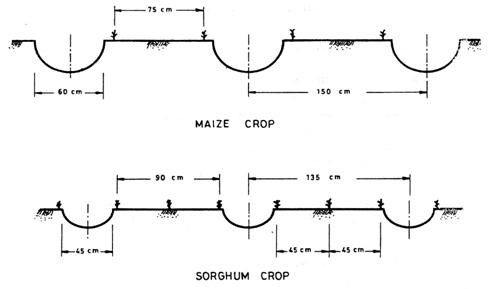
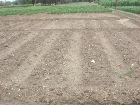
BROAD BEDS AND FURROWS
a. FUNCTION
To control erosion and to conserve soil moisture in the soil during rainy days.
b. GENERAL INFORMATION
The broad bed and furrow system is laid within the field boundaries. The land levels taken and it is laid using either animal drawn or tractor drawn ridgers.

BROAD BEDS AND FURROWS
  
c. COST
Approximate cost for laying beds & furrows is Rs.1800 / ha.
d. SALIENT FEATURES
  • Conserves soil moisture in dryland
  • Controls soil erosion.
  • Acts as a drainage channel during heavy rainy days.
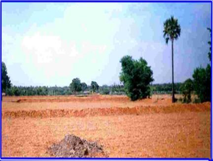
2. CONTOUR BUND
a. FUNCTION
To intercept the run off flowing down the slope by an embankment.

 
CONTOUR BUND


Contour bunding
Source: http://terra-agro.com/Company/bhj/images/wasteland1.jpg
b. GENERAL INFORMATION
It helps to control run off velocity. The embankment may be closed or open, surplus arrangements are provided wherever necessary.
c. COST
Approximate cost of laying contour bund is Rs.1400 / ha.
d. SALIENT FEATURES
i. It can be adopted on all soils
ii. It can be laid upto 6% slopes.
iii. It helps to retain moisture in the field.
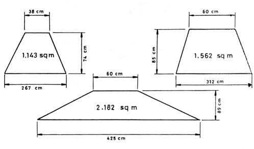
3. BENCH TERRACING
a. FUNCTION
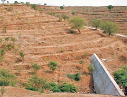
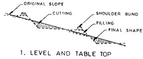
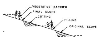
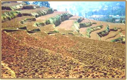
It helps to bring sloping land into different level strips to enable cultivation.


Text Box: 4. PUERTORICO TYPE TERRACE
Text Box: TYPES OF BENCH TERRACES

TYPES OF BENCH TERRACES
b. GENERAL INFORMATION
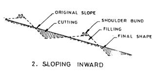
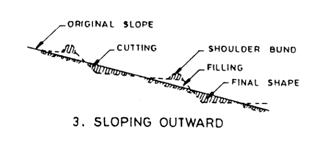
It consists of construction of step like fields along contours by half cutting and half filling. Original slope is converted into level fields. The vertical & horizontal intervals are decided based on level slope.
c. COST
Approximate cost for laying the terrace is Rs.5000 / ha.
d. SALIENT FEATURES
  • Suitable for hilly regions.
  • The benches may be inward sloping to drain off excess water.
  • The outward sloping benches will help to reduce the existing steep slope to mild one.
  • It is adopted in soils with slopes greater than 6%
 
4. MICROCATCHMENTS FOR SLOPING LANDS
a. FUNCTION
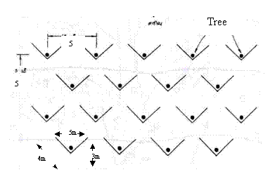
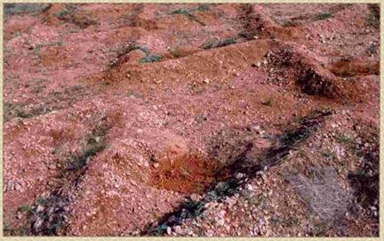
It is useful for insitu moisture conservation and erosion control for tree crops.

     
   MICROCATCHMENTS

 b. GENERAL INFORMATION
Technique
Storage capacity
per unit  (m3)
Annual run-off contribution to soil moisture Additional water stored per ha (m3)
Estimated surface Run-off control
(%)
Triangular catchments (V-Bunds)
13
5200
80
Crescent bunds
10.2
4080
73

c. SALIENT FEATURES
  • Slope ranges from 2 –8%
  • Soil type – Light to moderate texture
  • Insitu moisture conservation with staggered planting
  • Suitable for dry land Horticulture & Agroforestry
  • Bund height – 30 to 45 cm.
5. Check dam
Salient features
  • A low weir normally constructed across the gullies
  • Constructed on small streams and long gullies formed by erosive activity of flood water
  • It cuts the velocity and reduces erosive activity
  • The stored water improves soil moisture of the adjoining area and allows percolation to recharge the aquifers
  • Spacing between the check dams water spread of one should be beyond the water spread of the other
  • Height depends on the bank height, varies from a metre to 3 metre and length varies from less than 3m to 10m         
  • Cost varies from Rs. 40000/- to Rs. 100000/- per unit depending upon the size. 
6. Percolation pond:
Function
To augment the ground water recharge
Salient features
  • Shallow depression created at lower portions in a natural or diverted stream course
  • Preferable under gentle sloping stream where narrow valley exists
  • Located in soils of permeable nature
  • Adaptable where 20-30 ground water wells for irrigation exist with in the zone of influence about 800 – 900m
  • Minimum capacity may be around 5000 m3 for the sack of economy
  • Also act as silt detention reservoir.
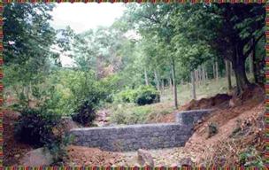
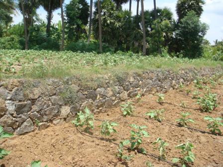
7. Stone Barriers or Boulder Bunds

What is Agricultural Engineering

Agricultural engineering incorporates many science disciplines and technology practices to the efficient production and processing of food, feed, fiber and fuels. It involves disciplines like mechanical engineering (agricultural machinery and automated machine systems), soil science (crop nutrient and fertilization, etc.), environmental sciences (drainage and irrigation), plant biology (seeding and plant growth management), animal science (farm animals and housing) and much more.
Areas of interest to Agricultural Engineers
  • Design of ag. machinery, equipment, and structures
  • Environmental control systems, cooling and ventilation
  • Energy Conservation
  • Crop production-seeding, tillage and irrigation practices
  • Soil & water conservation
  • Animal production and care
  • Biofuel production and utilization on the farm
  • Post harvest processing, handling and storage
  • Precision farming technologies, machine vision, gps
  • Farm operations and management
  • Farm safety, security and ergonomics

Who are Agricultural Engineers 


Agricultural engineers must have a wealth of knowledge and skills to function effectively in the diverse agricultural and agribusiness industries. The agricultural engineer obtains training in design and engineering problem solving based on an understanding of engineering sciences including mathematics, physics and biology. They must also have skills in computers, communication, teamwork and instrumentation. The feature distinguishing agricultural engineers from other engineers is their interest and commitment to solving agricultural problems.
Agricultural engineers are employed as:
  • Researchers
  • Extension Specialists
  • Waste Specialists
  • Soil and Water Conservation Specialist
  • Watershed Management Specialist
  • Farm Mechanizations Specialist
  • Land Development Engineer
  • Structure Designers
  • Machinery Designers
  • Electrification and Power Systems Designer
  • Precision Agriculture Applications Engineer
  • Environmental Controls Engineer